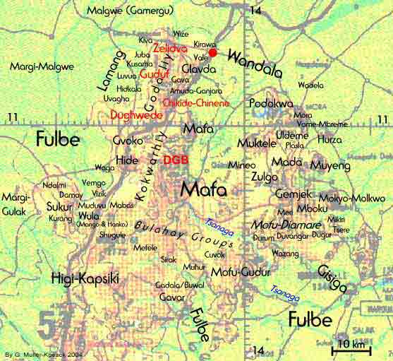
On the map to the right the location of the DGB sites and the Godaliy groups of the Gwoza Hills are in red to highlight their geographical vicinity.
I first came across the word Godaliy among the Vreke of Moskota (to the north of the DGB sites) in 1988. The Mafa there use it to refer to the montagnards of the Gwoza Hills. They also claim that the "Godaliy" and the Glavda once occupied their territory. A literal translation for Godaliy could not be obtained. However, it shares a semantic similarity with the word Kokwarhiy (kokwar = mountain village, hiy = plural). The map shows the so-called Kokwarhiy on the high mountains to the east of the DGB sites. Mafa say that, like the Kokwarhiy, the Godaliy occupy the mountain heights. They have a preference for stone architecture and are considered as "true montagnards".
The Mafa claim of a link between the DGB sites and the Godaliy is supported by the fact that the so-called Godaliy themselves claim to have moved to their present territory from a southerly direction, mainly from the Hide (Tur) area. Neither the Hide nor the Gvoko (living next to the Dughwede) use funnel pots with small openings.
I have included Kirawa town, an old Wandala settlement, in this map. The Dughwede tend to include the Wandala in their genealogy by claiming that they share an apical ancestor but the Wandala deny having descended from the Gwoza Hills.